Vol. 7, Issue 2 (2019)
Land evaluation of Adavibhavi micro-watershed to derive land capability and its suitability for field crops and horticulture crops
Author(s): Rajesh NL, Rajesh V, Meenkshi R Bai, Sathishkumar U, HV Rudramurthy and RB Hiremat
Abstract: A detailed study was conducted to assess the land capability and land suitability of Adavibhavi micro watershed. The micro watershed is located in Lingasugur taluk, Raichur district, Karnataka, India, which lies between the latitude and longitude of 160 9’- 16081 North and 760 27’ -76029’ East. Initially, land resource survey was carried out at 1:8000 scale to derive soil phase units based on land surface and profile characters. Three soil series were identified and further mapped into nine soil phases units were identified. The soil phase unit “ADBhD2g1S1R1†covered maximum area of 154 ha (30.44%) with moderate slope (5-10%) and moderate erosion in Adavibhavi micro-watershed. Land capability with subclasses in the study area was IIIes and IVes having limitations of soil erosion, texture, soil drainage, soil fertility and topography. Suitability for agricultural crops showed that, an area of 259 ha (52.80%) was moderately suitable (S2) for Green gram, Ragi, Bengal gram and Black gram with limitation to topography and texture. In case of horticultural crops, about 312 ha (61.60 %) was marginally suitable (S3) for Custard Apple and Amla with limitations of rooting condition and topography. Soil phase unit wise crop plan with suitable interventions for field crops, horticultural crops, vegetables, millets and pulses were developed.
Related Graphics: Click here for more related graphics
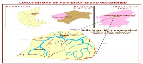
Fig. 1: Location map of Adavibhavi micro watershed
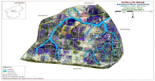
Fig. 2: Cadastral map overlaid on Contrasat-I merged with LISS IV covered by Adavibhavi micro watershed
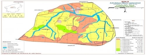
Fig. 3: Area distribution of soil phase mapping unit of Adavibhavi micro watershed
Pages: 160-172 | 664 Views 60 Downloads
download (33548KB)


How to cite this article:
Rajesh NL, Rajesh V, Meenkshi R Bai, Sathishkumar U, HV Rudramurthy, RB Hiremat. Land evaluation of Adavibhavi micro-watershed to derive land capability and its suitability for field crops and horticulture crops. Int J Chem Stud 2019;7(2):160-172.